


Deer Scouting Theory - It Starts with the Hills and Valleys
Understand the kitchen and the bedrooms

The song Hills and Valleys is one of my favorite worship songs. When it comes to scouting a brand new property, that’s the song that comes to my mind. First, because it’s a great reminder of who created the land, whom I’m created to glorify, and that I am just a footnote in this land’s history. Second, because it outlines my scouting strategy – understanding the hills and valleys.
What are your goals?
Before we dive into how to decipher the hills and valleys, it’s vitally important to remember why you want to hunt that property. What are your hunting goals? If you haven’t answered that question, go back and read the linked article in the previous sentence. Understanding this will help dictate what you look for and most importantly, what you should get excited about (and not). Since I’m a Basic Hunter, my goals are to fill the freezer every year and to kill a buck of my desired maturity (admittedly younger than 4+ years old).
I start every property with the food-water-cover principle. I want to know where the deer generally bed, where they eat, and how they move about the property to accomplish these tasks. It helps me to use the analogy of the new property as the deer’s “house”.
What’s the Kitchen Like?
If I look at most two-story houses, generally the bedrooms are upstairs and the kitchen is downstairs. Families sleep upstairs in separate rooms and eat together downstairs. The hills and valleys of a property generally work the same way. Deer will bed ‘up’ where they feel safe and secluded, and eat ‘down’ in fertile territories where there’s food. So, the higher elevations of a property will generally be bedding, and the lower elevations will generally contain food.
Before anyone write this off, I use the term ‘generally’ here because it’s a place to start. I understand that oak ridges can have food up high and a swamp donkey may be found bedding in the lowest elevation imaginable. I’m saying understanding how deer use hills and valleys in a general sense is a good place to start, given the bell curve of properties one may run into across our nations landscape.
The terms ‘hill’ and ‘valley’ are also relative terms in this case. Many people conjure up images of the Rocky Mountains when they hear those words. I am simply using them to mean the high ground and the low ground of a property. That elevation change may only represent a few feet, or maybe none at all. The point is simply this – deer spread out to different bedrooms at night (usually up higher), and congregate for dinner together (usually down lower). I get there might be a basement bedroom a sulky buck might prefer, but this is your starting point. You will progress from here for your actual theory.
Start with a Basic Theory
My goals include both bucks and does, so it’s important to understand how these hills and valleys (or kitchen and bedrooms) impact each gender differently. For bucks, they like the ‘basement bedroom’ to hide from everyone else. Once the rut comes around, however, they will look both high and low for receptive does, so that means they will check all of the bedrooms as well as the kitchen. When it comes to bucks, I want to see how they cruise around the land to check all of these spots.
For does, I want to see how they cruise between the bedrooms and the kitchen. What paths do they take? Does are generally less concerned about the breeding season, and they usually stay together in groups (as opposed to bucks, who will generally be loners). Is there a ‘kitchen’ on the property that I can use to pattern a doe? Is there a ‘bedroom’ up at higher elevation that I know they’ll be leaving from to head out to the ‘kitchen’ down low? These are the starting points for my theory about a property.
I rely heavily on e-scouting to develop a theory about the hills and valleys. Satellite imagery can do a great deal for understanding where there are perennial ag fields to understand the ‘kitchen’ aspect. These are usually found in the valleys because valleys are generally flatter (and thus farmers can plant them). I’ve found the same to be true in mountainous areas – fruit and nut-bearing trees will generally grow in flatter terrain, although that becomes less true in the mountains than it does in farmland.
Topography - French Word for ‘Jumble of Lines’
To truly understand the hills and valleys, you need to understand topography (or ‘topo’) lines on a map. These lines could be confusing to a new hunter but they are simple to read once you understand the concept. I will do a deeper dive into topographical maps in the future, but here’s the basic rule: the closer the lines are together, the steeper the elevation climb on the map.
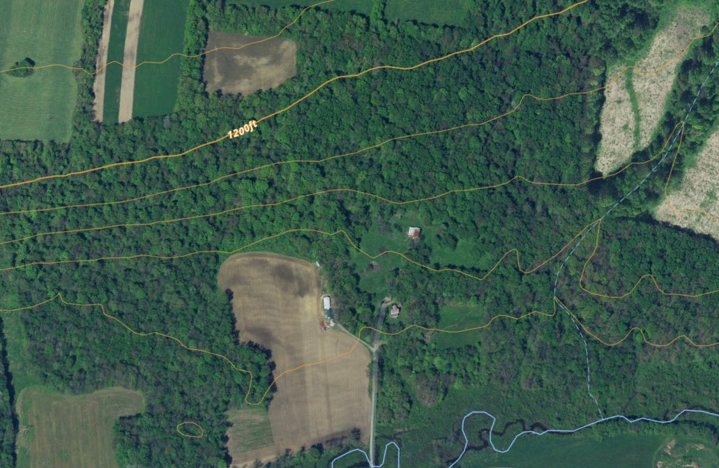
Here is a map of a recent property to which I gained permission. You can see near the top of the map a bolded line with ‘1200’ – this line represents 1,200 feet of elevation above sea level. The other lines represent a change in elevation – usually 10 feet depending on the scale. So, you can see the next three lines down from the ‘1200’ line are much closer than the next line up. As you get closer to the bottom of the map, you see a blue line indicating a creek. The lines begin to spread out much further as you get closer to the creek.
Here’s Where That Physics Class Comes In Handy
You might ask yourself ‘how can you tell which way is up and which way is down?’ If you don’t have a second elevation line to tell you if the lines represent a rise or a fall in elevation, there’s always Newton’s third law as it applies to gravity and water – what goes up, must come down. All water flows downhill. So, in this picture, which way is down? Look for where the water gathers – namely, the creek. That’s how you know which was is up, and which way is down.
This is a great representation of hills and valleys. The lines that are close together show that there’s a quick 40-50 feet of elevation change in a short period of time (i.e. a hill). As the lines get further apart, this represents a gentler elevation change (i.e. a valley). So, if I go back to my kitchen and bedroom analogy, my theory is that I will see a lot of sign down in the valley near the fields, where the deer congregate in the kitchen. I also believe they will bed higher up on the hills (near the closer lines of elevation.)
That’s my theory – the deer are bedding somewhere on the hill, and coming down to the food at night. Next week, I’ll dive into how I specifically approach boots on the ground scouting to prove (or disprove) my theory.